
- 98
- 6 120 534
Learn & Explore
India
Приєднався 3 кві 2017
Get advanced tutorials in Land Surveying!
Tutorials related to the softwares which are broadly used in Surveying Field like
AutoCAD, Excel, AutoLISP, Excel VBA, Civil 3D, Road Estimator, QGIS, MapIt etc.
SUBSCRIBE us and stay connected :-)
Please JOIN our YT Membership to show your support.
Click here to JOIN: ua-cam.com/channels/PFKMG7jmWV9zlQ_9WhNrMg.htmljoin
Best of Luck!
Learn & Explore Team!
Export Coordinates of Vertices from a Polygon Shapefile using QGIS
In this QGIS tutorial, we'll show you how to export the coordinates of vertices from a polygon shapefile. Whether you're working on geographic analysis, data visualization, or simply need to extract spatial data, this step-by-step guide will help you harness the power of QGIS, a powerful open-source GIS software.
Additional Resources 🔗
QGIS Download: www.qgis.org/en/site/forusers/download.html
📌 Prerequisites 📌
Before we begin, make sure you have QGIS installed on your computer. You can download it for free from the official QGIS website (link provided above).
📝 Step-by-Step Guide 📝
Launch QGIS: Open QGIS on your computer.
Load/Create Your Shapefile: Use the "Add Vector Layer" tool to load your polygon shapefile into QGIS. Or make a polygon in temporary layer
Enable the Vertex Tool: Click on the "Toggle Editing" button in the toolbar, then select the polygon layer you want to work with.
Select a Polygon: Click on the polygon you want to extract vertex coordinates from. It should now be highlighted.
Access Vertex Coordinates: Click on the "Vertex Tool" in the toolbar. This will allow you to interact with the vertices of your polygon.
Change attributes table: Right-click on the layer and make changes in attributes. Apply expression to update lat long values.
Customize Export Options: In the new layer, right-click and choose "Save As." Select the format as CSV and configure any additional export options you need. During export choose projection system as UTM and geometry as XY.
Save the CSV File: Choose a location to save your CSV file, and click "Save."
Import Data into Excel: Open your CSV file in a spreadsheet software like Microsoft Excel to view and work with the extracted coordinates.
By following these steps, you'll be able to export vertex coordinates from a polygon shapefile using QGIS. This valuable skill can be applied to various GIS and spatial data analysis projects.
Don't forget to like, share, and subscribe for more QGIS tutorials and geospatial tips. If you found this video helpful, please leave a comment and let us know what other QGIS topics you'd like to learn about. Thanks for watching! 🌍🗺️ #QGIS #GIS #Geospatial #Shapefile #Tutorial #Mapping #Coordinates #DataExport
Переглядів: 5 896
Відео


DGPS Data Processing with TBC Software and CORS Network | Learn & Explore YT
Переглядів 4,4 тис.Рік тому
Welcome to Learn & Explore YT, your go-to channel for all things related to surveying and geospatial technology! In this video, we dive into the world of DGPS data processing using TBC Software and CORS Network. DGPS (Differential Global Positioning System) is a technique that improves the accuracy of GPS positioning by using reference stations known as CORS (Continuously Operating Reference St...

Chain Surveying MCQs 50 Most Important questions for Competitive Exams
Переглядів 6 тис.Рік тому
Here are the 50 most important MCQs in chain surveying from Learn & Explore UA-cam Channel. This Chain surveying MCQs are very helpful for survey and civil engineers who are preparing for competitive Govt jobs where surveying is part of the syllabus. Earlier We have uploaded 100 most important MCQs in surveying and Civil. Keep watching our videos and be confident before appearing in a competiti...
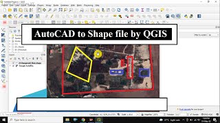
AutoCAD to Shape File by QGIS | DWG to SHP
Переглядів 19 тис.2 роки тому
In this video I have shown the method of how to convert an AutoCAD drawing file to Shape file by using QGIS. QGIS is an open source GIS Platform. Steps I have used to create SHP file from a DQG file 1) Make DXF from DWG file. 2) Import DXF in QGIS 3) Set CRS (Coordinate Reference System) in Imported layer. 4) Export to Shape file i.e. .SHP 5) Making ZIP file o SHP which includes (.shp, .shx, .d...

How to Draw Contour in QGIS without visiting site | (English)
Переглядів 28 тис.2 роки тому
How to draw contour in QGIS in very easy method without visiting the site. First I have chosen an unknown location for drawing contour. Then I have created some regular points over there. Thereafter I have converted the points to KML format Then with the help of GPS Visualizer elevation website I obtained elevation data free of cost and converted it to GPX layer. Then imported the GPX layer in ...

How to Install QUICK MAP SERVICE PLUGIN in QGIS Software
Переглядів 18 тис.2 роки тому
Go to plugin menu then click Mange and Install Plugin. Then search for Quick Map Service PLugin and Install it. Then Go to Web Menu and the go to settings In the More services option click Get contributed pack. Now enjoy Google map or any satellite map like OSM, BING, ESRI etc. overlay in QGIS. Thanks for watching.

Complete DGPS Survey Tutorial | Leica GS18 RTK | Full Setup & Practical Video of DGPS Surveying
Переглядів 111 тис.2 роки тому
We are here with a Practical video on DGPS RTK. We have used DGPS of LEICA Model GS 18 which is fitted with RADIO system. Here we have shown BASE and ROVER setup and how to Collect topography data by DGPS RTK method, how to Import points, Export points, Code change, delete points, automatic record points etc. Video Location: India, Tawang. Watch this video full for better knowledge in DGPS RTK....
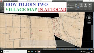
How to Join two Raster Image in AutoCad in Hindi | ImageClip command | Learn&ExploreYT
Переглядів 30 тис.2 роки тому
How to join two village maps in AutoCAD. In this video I have shown how to clip a boundary of an image in autocad. In cadastral map or village map the boundary of village is inside a rectangular paper. So, if one wants to keep two village boundary adjacent to each other then in physical they need transparent paper to do that. And when you have scanned Image of two adjacent village then you can ...

How to DIGITIZE a Scanned Village Map in AutoCAD | Raster to Vector
Переглядів 127 тис.2 роки тому
In this video I have shown how to digitise a scanned village map in AutoCAD. First you have to insert a scanned map in autocad. Then set scale and rotation to the scanned image which is called a Raster image. you can use either SCALE and ROTATE command or ALIGN command in autocad to prepare the image. This process is also used to convert a raster image to vector format. Watch the full video and...
Export Coordinates from AutoCAD to Excel in regular intervals via LIST and LOGFILEPATH COMMAND
Переглядів 41 тис.3 роки тому
In this session I have shown how to export coordinate data i.e. Easting Northing data from an alignment drawing in AutoCAD to Excel. If you have only a drawing of an alignment of Road project, Railway project or any other project and you want to export the chainage wise coordinate details then this video will be helpful to you. First, I applied MEASURE command to split the alignment in a fixed ...
How to Edit PDF online Free | www.sejda.com
Переглядів 5 тис.3 роки тому
In this video I have shown a trick of how to edit a PDF file online by FREE. All credit goes to www.sejda.com. How To Edit PDF Files Online For Free Edit & Sign PDF files online for free. Fill out PDF forms online. Change PDF text Add text to PDF. Edit existing PDF text. Add image to PDF Create links in PDF. Edit hyperlinks in PDF. Annotate PDF I have edited an Invoice from Amazon and saved the...
Long Section Excel Program | Excel to AutoCAD | Learn & Explore
Переглядів 15 тис.3 роки тому
Long Section Excel Program | Excel to AutoCAD | Learn & Explore
How to Plot AutoCAD Drawing in different Page size | How to set SCALE in AutoCAD
Переглядів 9 тис.3 роки тому
How to Plot AutoCAD Drawing in different Page size | How to set SCALE in AutoCAD
DGPS Survey Practical by RTK Method using CHCNAV i50/i80 DGPS
Переглядів 43 тис.3 роки тому
DGPS Survey Practical by RTK Method using CHCNAV i50/i80 DGPS
Theory of DGPS! Principal & Methodology | Every SURVEORs Should Know This!
Переглядів 120 тис.3 роки тому
Theory of DGPS! Principal & Methodology | Every SURVEORs Should Know This!
General Knowledge MCQ Question and Answer | Learn & Explore
Переглядів 1,8 тис.3 роки тому
General Knowledge MCQ Question and Answer | Learn & Explore
Important MCQs related to GIS and GPS | Part 2 | Learn & Explore
Переглядів 18 тис.3 роки тому
Important MCQs related to GIS and GPS | Part 2 | Learn & Explore
UTM to Lat Long by QGIS Software (English)
Переглядів 43 тис.4 роки тому
UTM to Lat Long by QGIS Software (English)
GeoLocation in AutoCAD | Google Map overlay in AutoCAD | Online Satellite Map in AutoCAD
Переглядів 87 тис.4 роки тому
GeoLocation in AutoCAD | Google Map overlay in AutoCAD | Online Satellite Map in AutoCAD
Open Traverse Theory & Excel Sheet for Correction | Land Surveying
Переглядів 53 тис.4 роки тому
Open Traverse Theory & Excel Sheet for Correction | Land Surveying
How to cast Phone Screen to Laptop or PC | Wireless Display | Cast | Projecting to this PC
Переглядів 74 тис.4 роки тому
How to cast Phone Screen to Laptop or PC | Wireless Display | Cast | Projecting to this PC
Theory of TOTAL STATION | How a TOTAL STATION Works! Working Principal of ETS!
Переглядів 65 тис.4 роки тому
Theory of TOTAL STATION | How a TOTAL STATION Works! Working Principal of ETS!
MOST IMPORTANT ADVANCED SURVEYING MCQ FOR COMPETITIVE EXAM|CIVIL ENGINEERING|RRB-JE|SSC-JE AE
Переглядів 14 тис.4 роки тому
MOST IMPORTANT ADVANCED SURVEYING MCQ FOR COMPETITIVE EXAM|CIVIL ENGINEERING|RRB-JE|SSC-JE AE
Part II - 100 MOST IMPORTANT CIVIL ENGINEERING MCQ FOR COMPETITIVE EXAM|RRB-JE|SSC-JE, AE 2019 2020
Переглядів 24 тис.4 роки тому
Part II - 100 MOST IMPORTANT CIVIL ENGINEERING MCQ FOR COMPETITIVE EXAM|RRB-JE|SSC-JE, AE 2019 2020
Import XYZ Points from Excel csv to AutoCAD | Excel Program
Переглядів 16 тис.4 роки тому
Import XYZ Points from Excel csv to AutoCAD | Excel Program
AutoCAD to Google Earth KML by CIVIL 3D
Переглядів 41 тис.4 роки тому
AutoCAD to Google Earth KML by CIVIL 3D
DGPS Survey Full Tutorial in Hindi | Trimble R5
Переглядів 67 тис.4 роки тому
DGPS Survey Full Tutorial in Hindi | Trimble R5
How to plot LONG SECTION of road in AutoCAD by EXCEL
Переглядів 126 тис.4 роки тому
How to plot LONG SECTION of road in AutoCAD by EXCEL
Top 10 Important Surveying Math Questions & Solution
Переглядів 10 тис.5 років тому
Top 10 Important Surveying Math Questions & Solution
Part I - 100 MOST IMPORTANT CIVIL ENGINEERING MCQ FOR COMPETITIVE EXAM|RRB-JE|SSC-JE, AE 2019 2020.
Переглядів 161 тис.5 років тому
Part I - 100 MOST IMPORTANT CIVIL ENGINEERING MCQ FOR COMPETITIVE EXAM|RRB-JE|SSC-JE, AE 2019 2020.
Sokia topcon ka gps chalaya tha kabhi kabhar same like Total station ke tarh hi he thoda connect karne ka tarika bataye
Sir mene jayda total station me survey kiya ,gps bhi kabhi kabhar chalaya hu mughe kia kia sikna padega or wo time ka setting nahi samag me aa raha he
Need the Excel file for education
Nice explanation thanks sir🥰
Welcome
THANKYOUUUU
how to print geolocation AutoCAD Drawing ??? Sir... please tellme sir.,
Accuracy kitna hota h? And minimum land area kitna measure kar sakte hain??
Thank you very much, you saved me !!! Have a great day
good
Can you explain how to prepare excell sheet for traverse by self and what's the formula used in excel
Thank you
This video help many people..
Where I sent you mail id , can you tell me please?
Can you please send the excel file links..
What if the Eastings and Northings of the first Station is not given?
Can we post any DGPS raw data to CORS
Excellent work
Sir please send link download formulas
Change music
Thanku you
Joom Thora kar ke bata bhai taki samagha me aa jaye base mai set kar leta ho controlar me pari Sani hoti hai
Kya parisani ho rha he?
Jo sinier hai puri tarah nahi samajhata hai yahi parisani hai keval base par baitha deta hai controlar nahi deta hai kai se chalaye aap se request hai hame batay taki ham chala le bahut din se sath me hai par kuchh nahi batata hai pls sir
Help me
hey! I just wanted to know, how did you convert your bearing to decimal? Thanks!
We have seperate video for that. Look for the video on our channel.
@@LearnExplore Sir I am really desperate to find out the coordinates of the technical description of a lot. I need to identify the coordinates of each point and the only data that I have is the technical description and its bearings with its distances. The point 1 does not have a coordinates, what should I do?
Good !
Thank u so so much brother 💐💐💐🙏🏻🙏🏻🙏🏻
Thank u bro🙏🏻🙏🏻🙏🏻🙏🏻
You are welcome
👍
hi
why take east as +ve and north has -ve
Thank you, sir! Greetings from Brazil!
Most welcome
Thanks, I did two other tutorials on how to install QGIS and for some reason neither of them showed this essential step leaving me baffled.
Oh really!🙂
Image ko lock kese krte hai
Isko alag layer me rakhkke layer ko lock kar do
Nice
Thanks
Very Poor Audio quality
nice
Not a good way of presentation
Very well explained
Thank you
If i purchase ur Excel sheet for L section for 3000 Rupees, is it free of will expair after some months, and for how many mtrs can L sec be made in it?
No it will not expire. You can plot upto 20km if it is 20m intervals
You can repeat the process to plot unlimited km
❤❤😂❤❤
How to download Qgis software please reply
Fast & Furious Plotting..
I am unable to download the Excel file..
Please share it..
NOT HELPFULL, I HAVE PURCHESED TAVERSE CALCULATION SHEET BUT IT'S CAN'T WORKING ALL ARE SHOWING ERROR MONEY WASTE.
Don't worry. Your money is safe and no waste.
I hope the problem is solved now
@@LearnExplore YES IT'S SOLVED THANK YOU.
Sir DGPS ka course jharkhand me hota h kya , ?
Currently I don't have any related software to download survey data in excel format. If I get this it will be a great help for me and my team. Thank you very much for helping us.
how to download that software? pls give me a link. teach me how to download
Ye location kha ka he??
thank you
Background music should not be added in studying videos
7 d ann 17 a 19 c
❤Great video. Thanks sir.
Amazing
Thanks